Geology Landscapes of Valencia County
For hundreds of years, the wide and resilient system of acequias in Valencia County provided effective, community-based irrigation management for farmers.
The present set of water management ditches was designed in the 1920s and completed in the 1930s with the formation of the Middle Rio Grande Conservancy District. What forced the formation of MRGCD and the extensive construction of hundreds of miles of new ditches merging with the existing older acequias?
In the early 1900s, widespread agricultural development in Southern Colorado created negative impacts in downstream central New Mexico with reduced Rio Grande water flow rates and increased silt. The silt filled the former river pathways, and this caused a much wider riverbed, with water reaching farther away from the initial Rio Grande bed and resulting in devastating floods.
Higher river water levels also created groundwater levels too shallow for crops along the sides of the river, and flooded areas that dried up in summer months left behind salty (alkali) areas where no crops would grow.
The MRGCD plan included interior drains to maintain deeper groundwater in agricultural areas, riverside drains on each side of the Rio Grande to prevent spreading of water from the river into agricultural areas, a water storage dam (El Vado Dam), and three diversion dams, including Isleta, that feed irrigation canals for agricultural areas.
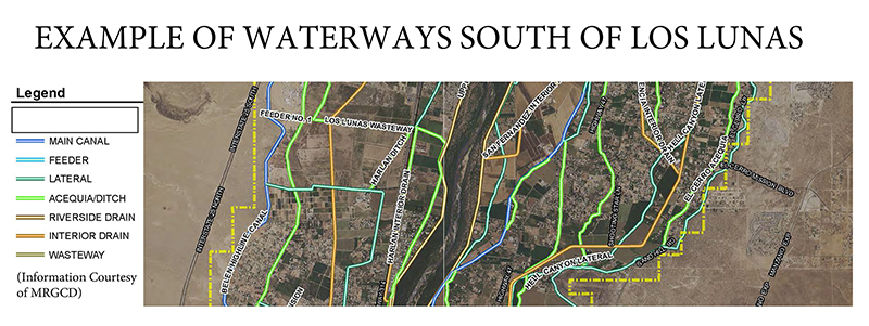
This complex canal system in our county results in alternating canals that provide irrigation water and drainage ditches (see figure of ditches in southern Los Lunas) that you can encounter as you drive around the county, with drainage ditches typically deeper than irrigation ditches. The drainage ditches also typically have water year-round.
The “History Section” on the MRGCD website includes a very instructive copy of the original 1920s plan that describes the adverse conditions in 1920s and proposed solutions.
The controversial formation of MRGCD and its associated fees and taxes forced many farmers to lose their land; and the acequias in the county are no longer managed by traditional, community-based acequias. However, the set of ditches built in the 1930s combined with the ancestral acequias allows the MGRCD to now effectively manage water distribution in Valencia County.
(Paul Parmentier, a certified professional geologist retired from California and living in Los Lunas, shares the rich geologic features in Valencia County. He earned a Bachelor of Science degree in geology from Belgium and a master’s degree in geochemistry from Japan. The Geology Landscapes of Valencia County are featured monthly.)


