La Vida
People have erected monuments for thousands of years. Some, like the Egyptian pyramids (circa 2500 BCE) and Stonehenge on the Plains of Salisbury (circa 700 BCE), are vertical, but some are laid out on barren plains or on the sides of mountains.
The monuments, referred to as geoglyphs, have been erected for a variety of purposes — religious reasons, astronomical observations, or proofs of the power of their erectors.
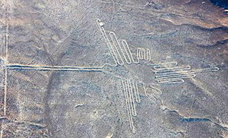
Consider, for example, one of the largest such horizontal monuments, the geoglyphs on the plains of Nazca in the Peruvian desert (circa 200 BCE). These monuments are so large that they can only be viewed in their entirety from nearby hills or from the air. For example, the hummingbird is 305-feet long.
The Hummingbird
The Nazca geoglyphs are generally believed to have religious significance, perhaps constructed to be visible to deities in the heavens. This has also given rise to several alien/UFO theses!
The modern world has adopted this idea, albeit on a much smaller scale. Instead of giant geoglyphs, I am referring to what are generally termed mountain monograms — the letters that are placed on hillsides to call attention to some feature of the nearby locality. Perhaps the letter is just the first letter of the nearby town, but many times it is a symbol of one of the major schools in the area.
Richard Melzer photo
Mountain monogram in Raton.
There are 37 mountain monograms in New Mexico. This is in stark contrast to Montana, which is credited with 86, and California which has 84.
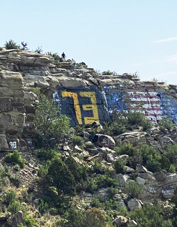
Over the years, if one drove from Las Cruces to Raton, 12 monograms would have been visible. Although several of these are no longer maintained, it is clear that local communities and schools were proud enough of themselves to go to some difficulty in putting these symbols on nearby hills. In fact, members of Raton High School’s class of 1973 inscribed their class year in a location that was so precarious that it could only be accessed by rope.
We will examine four such monograms that grace or have graced hillsides in the Rio Abajo. Moving from south to north, we have the M on Socorro Peak, the B on the west side of Interstate 25 near Belen, the double L on El Cerro de Los Lunas, and the J on Volcan, the largest of the dormant volcanoes that are west of Albuquerque.
The M on Socorro Peak
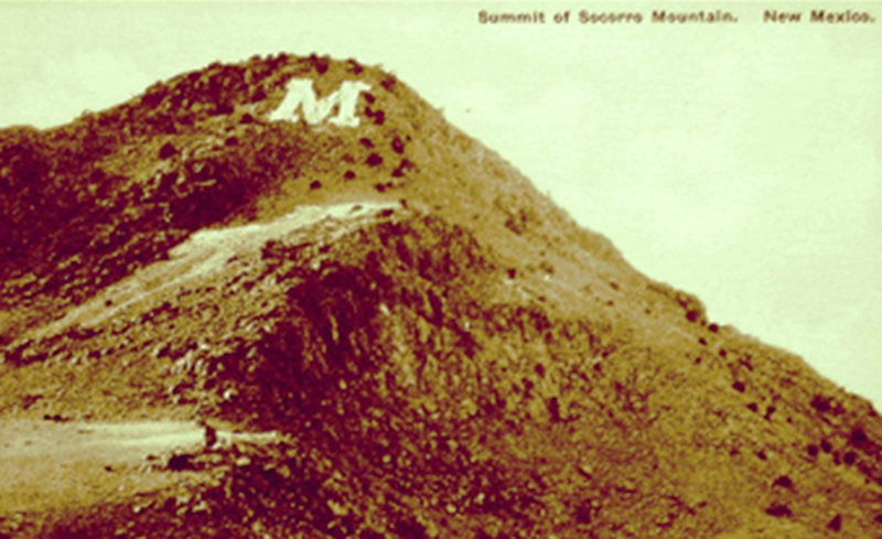
The M that is visible for miles on Socorro Peak dates to the early part of the 20th century. The idea of putting the letter on the east slope of Socorro Peak is attributed to Harold Lyons of the New Mexico School of Mines (now New Mexico Institute of Mining and Technology) class of 1913.
The monogram is 150-feet tall, 110-feet wide, and the lines are 30-feet wide. Some claim this monogram is the largest, the highest, and the most remote of all the monograms in the West and so has been crowned, as only engineering nerds could, “The Monarch of Mountain Top Mascots.”
El Defensor Chieftain photo
Postcard of the M on Socorro Peak.
Whitewashing the monogram has become a freshman ritual. Typically, it occurs after the first major snowfall because considerable water is needed to dissolve the approximately 500 pounds of lime necessary to paint the stones with brooms, and no one wants to carry that much water all the way to the top of the peak, a nearly 2,700 foot vertical climb.
The M was backfitted with a lighting system in 1962 so that it could be viewed at night. In addition, the lights can be adjusted to change the M to a W when it is time for the homecoming or other special events at Socorro High School, home of the Warriors.
Another ritual associated with the M was the Elfego Baca Golf Shoot. A set of intrepid golfers would tee off from a wooden platform next to the M in a contest to see who can hole out at the golf course several thousand feet below on the New Mexico Tech campus. Players were allowed ten balls and three spotters who try to find the balls while watching out for rattlesnakes.
Most participants took between 18 and 20 strokes, but the record is held by Socorro native, Mike Stanley, who holed out in nine strokes with an incredible average of 587 yards per stroke. Unfortunately, this unique event is no longer conducted.
The B in Belen
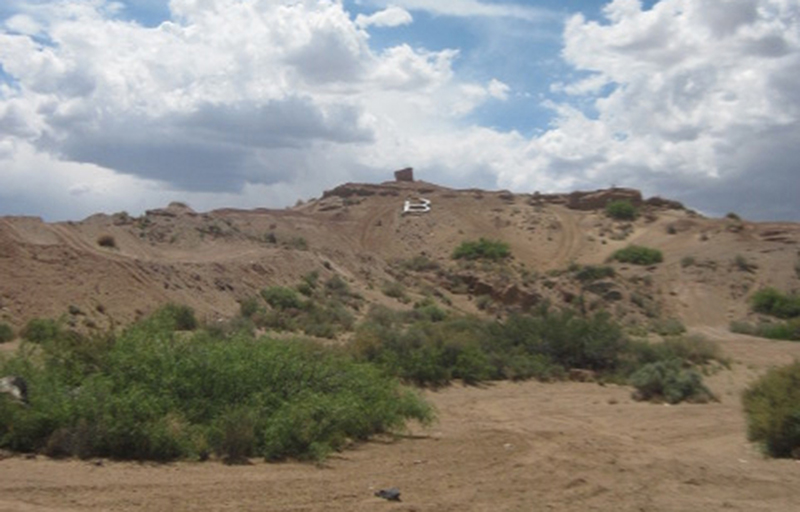
The B on a hillside west of Interstate 25 in Belen dates back several decades. Some have hypothesized that it had nothing to do with Belen High School but was an indicator of the nearby Belen airstrip.
Richard Melzer photo
The B in Belen.
Those were the days before any sort of electronic or even light-based navigation existed, so pilots, especially those who might be using the Rio Grande as a feature for terrain guidance, would look for visual clues on the ground to help them locate nearby landing facilities. A pilot flying along the river would see the B because it was on an angle facing the valley rather than on the flat area in town near the airfield.
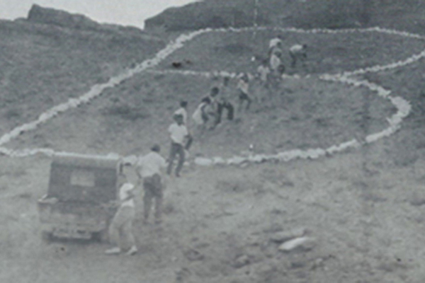
For a time, the B languished until it was taken over by students from Belen High School. It became a sophomore class ritual because the freshmen were in ninth grade, which was still held at the junior high school.
The class of 1984 poured the concrete to replace the rocks on the monogram, and subsequent classes have sometimes painted or whitewashed the monogram.
-

-
El Aguila (Belen High School Yearbook), 1966
Students refurbishing the B in 1966.
-
-
El Aguila (Belen High School Yearbook), 1966
The lighted B visible from the Belen football field in 1966.
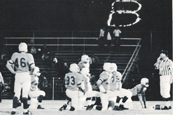
Like the M in Socorro, the B was lighted for special events. Since it is literally “across the road” from the high school, it could be seen by both fans and players at local football games.
The tradition of restoring the B ended around 2020 when the property was sold and access to the site was no longer available. In fact, the Google Earth map of the area indicates that the area is “closed.”
(Next week’s article will feature the double L on El Cerro de Los Lunas, and the The J on Volcon in Albuquerque.)
(La Historia del Rio Abajo is a regular column about Valencia County history written by members of the Valencia County Historical Society.
The author of this month’s column is John Taylor, a retired engineer from Sandia National Laboratories and board member of the Valencia County Historical Society. He is the author or co-author of 21 books on New Mexico history, including “Murder, Mystery, and Mayhem in the Rio Abajo,” “A River Runs through Us,” “Tragic Trails and Enchanted Journeys,” “Mountains, Mesas, and Memories,” “Years Gone by in the Rio Abajo,” and “History Surrounds Us,” all co-edited with Dr. Richard Melzer.
Opinions expressed in this and all columns of La Historia del Rio Abajo are the author’s only and not necessarily those of the Valencia County Historical Society or any other group or individual.)


